|
|
The
Barguzin valley, The Barguzin mountain ridge, The mineral springs of Barguzin
valley.
 The
Barguzin valley. The name of the valley originates from the local
word “Bargut,” which means “outskirts, wilderness.”
It was the name of a Mongolian tribe that used to inhabit the valley.
The country of Bargudzhin-Tukum –“the country of light ”
–is often mentioned in the “Secret Tales of Mongolia,”
an early chronicle of Mongol history. It says that in the 12th century,
Bargut tribes did not fight against Genghis Khan becauseGenghis Khan’s
mother originated from the area. They even supplied soldiers for Genghis
Khan’s army. The
Barguzin valley. The name of the valley originates from the local
word “Bargut,” which means “outskirts, wilderness.”
It was the name of a Mongolian tribe that used to inhabit the valley.
The country of Bargudzhin-Tukum –“the country of light ”
–is often mentioned in the “Secret Tales of Mongolia,”
an early chronicle of Mongol history. It says that in the 12th century,
Bargut tribes did not fight against Genghis Khan becauseGenghis Khan’s
mother originated from the area. They even supplied soldiers for Genghis
Khan’s army.
Even today, from the air, one can observe the irrigation canals made by
those ancient people. Numerous Bargut antiquities, including iron and
bronze items similar to those made by Chinese,provide evidence that the
tribe used to inhabit this land. Among the well known ancient sitesare:
the remains of a dam and a mill, a cave with inscriptions made in Mongol
and Tibetan near the Bannoy River, a stele with Bargut inscriptions near
the Khargana settlement in the Kuitun steppe, a sanctuary at the Kladovo
settlement, and the Bukhe-Shulun rock near the Suvo village.
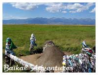
The
Barguzin valley is famous for its numerous mineral springs and picturesque
rocks on slopes of the Ikat ridge. There are some beautiful sites such
as the Suvinsky rockfaces (400 m. long and 50 m. high), the stones of
Uher-Shulun, Gribok (Sphynx), the Kamnigs rockface. The valley is located
in the intermountain hollow with a length of 200 km and its widest part
of 35 km at the Barguzin village. The total area of the Barguzin valley
is 3,100,300 hectares. The Dzherginsky National Park,founded in August
1992, covers an area of 238,700 hectares in the valley.
The
Barguzin River flows into the Barguzin valley. It is the third largest
tributary of Baikal, after the Selenga and Upper Angara. The length of
the river is 416 km, its slope is 1344 m. and its average downward slope
is 2.8%. The Barguzin River splits into several branches in the valley’s
middlesection. A number of lakes converge here, making a common river
web with an impassible swamp and an underbrush of tall reeds full of natatoriums.
The number of such lakes is about 1076 with an area from 2 to 10 hectares.
In the northwest, the valley is bordered by the very steep Barguzin Alps
(2840 m) and less steep (2558 m) forest-covered Ikat slopes on its southeast.
The mountain part of the Barguzin valley attracts many tourists and climbers.
There are good footpaths along the valleys of the mountain rivers and
up to mountain passes and peaks with numerous waterfalls, ice kars, and
lakes. The mountainous ranges are covered with thick forest – taiga
with cedar pine prevalence. Also one can find rhododendron, leather bergenia
lying on grassed covered thickets.
The
main asphalted motorway passes at the bottom of the Barguzinsky mountain
range along both the right and left banks of the Barguzin River. There
are good footpaths along the mountain rivers and valleys. The valley is
inhabited and well developed. The population is 30,000 people, of which
30 % are Buryats.
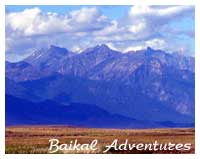 The
Barguzinsky Mountain Range. The
Barguzinsky Mountain Range.
The Barguzinsky Mountain Range occupies more than one third of the eastern
coast of Lake Baikal, stretching for about 300 kms along the lake from
the North to the South from the valley of the Upper Angara River. Its
width in the North is about 80 kms, and in the South, in the Chivyrkuiski
hills is about 30 kms. The average height of its peaks is under 2400 m,
with the highest peak measuring 2841 m (Baikal). The Barguzinsky Mountain
Range is the most impressive and the highest among ranges surrounding
Baikal. It is made up of many pointed peaks, towers, needles, pyramids
and the trapezes composed from hard minerals in the high mountainous part
of the range. One can find traces of comparatively recent glaciers in
the form of small modern glaciers, morenny deposits. The valleys of the
rivers resemble a trough with crossbars and ledges, lined with numerous
waterfalls and cascades. The highest of themis on the tributary of the
Tompudy River, the Tykma. It reaches about 300 meters in length. In the
upper parts of the range there is a set of glacial lakes. . The eastern
slopes of the range (from the side of the Barguzin River), especially
in the central part, have steep precipices which face the valley as rocky
walls, and the western slopes have spurs cut by abounding in water tributaries
of Baikal, gently sloping aside the coasts of the lake.
The Springs of Barguzin Valley.
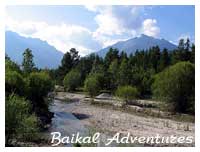 The
Allinsky springs are located 8 km to the West of Alla village,
not far from the Kuchegersky springs. Hot water with temperatures ranging
from +55C up to + 75C emerges at the bottom of the Barguzin Mountain Ridge
in the valley of Alla. There are 46 outlets of mineral waters with considerable
contents of sulfate hydrocarbonate structure. The valley of the river
is trough shaped; it was made by ancient glacier. The river flows in the
narrow canyon-like gorge. The springs are very popular and actively visited
by not only local people but also tourists. The
Allinsky springs are located 8 km to the West of Alla village,
not far from the Kuchegersky springs. Hot water with temperatures ranging
from +55C up to + 75C emerges at the bottom of the Barguzin Mountain Ridge
in the valley of Alla. There are 46 outlets of mineral waters with considerable
contents of sulfate hydrocarbonate structure. The valley of the river
is trough shaped; it was made by ancient glacier. The river flows in the
narrow canyon-like gorge. The springs are very popular and actively visited
by not only local people but also tourists.
The
Garginsky spring is very famous for its mineral water. The spring is located
33 kms from the Mogoito settlement in the valley of the Gargi River. The
spring thermal water emerges from rock cracks on the right hill of river’s
valley of the Ikat ridge at a height of 100 meters. The water emerges
in the form of travertine sedimentation. Its temperatures range from +
74C up to +75C. According to the chemical components they are sulphatic
natrium waters with contents of radon (from 35 to 43 eman). The water
of the spring is similar to that of the Nilova Pustyn Resort in its mineral
composition.
In addition to the healing properties of thermal water, the picturesque
mountainous area with its beautiful thick forest, mountain fresh air,
and fast mountainous river with ice clear water make the Garginsky spring
quite popular among visitors. The visit to the spring in 1775 by well
known Russian academician and traveler I.G. Georgi also demonstrates the
significance and wide popularity of the spring. He was the first to investigate
the springs and evaluate the curative properties of its water. Indeed,
due to its healing qualities, the springs have become a resort of regional
importance.
The
Kuchigersky mineral springs are located 4 –5 kms from the
village of Ulynhan at the northwest part of the Barguzin ridge. An interesting
feature of the spring is its widely varying temperature: its range goes
from +21C up to +75C, with a hydrosulphuric content of 29 mg/l. The springs
are very famous for their medical hydrosulphuric mud. The total area of
the mud is more than 40 thousand cubic metres. Although there have not
been analyses of the chemical, mechanical, microbiological structure of
the mud, it has been successfully used by local people for treatingrheumatic,
vessels and heart diseases.
The
Seyuisky spring is located in the Barguzin River valley on the
tributaries of the Haharhay River. The spring flows out from a dove-egg
shaped lake. The approximate size of the lake is 3 to 5 m. Being located
in pine forest, it is the perfect place forrelaxing. The type of water
is hydrocarbonate natrium. The debit of waters is 15 l/sm, mineralization
0,4 g/l, temperature +76C +77C, pH-9. The Seyuisky spring is a part of
the Dzherginsky Nature Reserve.
The Umheisky springs emerge on the ancient surface of a little island
at the upper Barguzin River and cover an area of 8 hectares. This beautiful
place has similar curative qualitiesas the famed Shumak and Goryachinsk.
The type of water is sulphide hydrocarbonate natrium. The temperature
of the water varies from 43C to 44 C.The Umheisky springs are the part
of the Dzherginsky Nature Reserve.
tour
programme
Let's
go!
| |
